In order to allow visitors to discover the different environments they encounter as they walk through the forest reserve, several stations have been set up where they can obtain detailed historical, cultural and scientific information. The information and activity suggestions can be accessed thanks to the digital support provided by the QR code. The content will be updated over time.
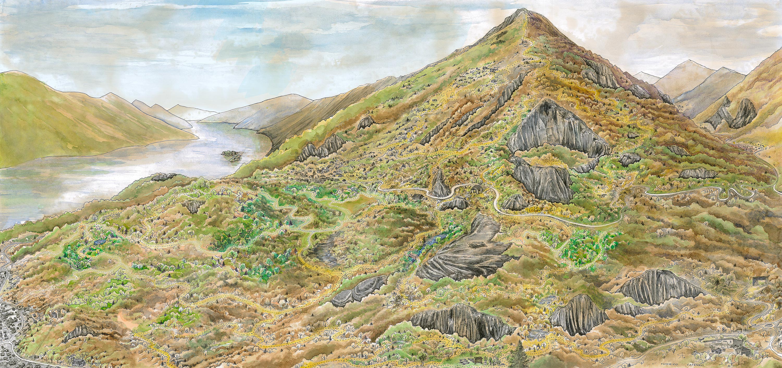
In order to allow visitors to discover the different environments they encounter as they walk through the forest reserve, several stations have been set up where they can obtain detailed historical, cultural and scientific information. The information and activity suggestions can be accessed thanks to the digital support provided by the QR code. The content will be updated over time.
1. The chestnut coppice
Human beings and the forest have a deep and ancient relationship. The techniques of management and exploitation have evolved, but the traces of anthropic influence remain an evident sign of our rural past. As in the rest of Ticino, here the chestnut has played a fundamental role for the subsistence and the economy of the past. The station is located along a steep shady slope, where the chestnut was managed as a coppice, that is cultivated to produce wood poles and firewood exploiting the ability of the tree stumps to emit basal shoots, with cutting shifts that varied from 6 to 30 years.
3. “Bolezzina longa”
In general, wetlands are rich in species that find ideal living conditions there. Within the perimeter of the Forest Reserve there are a good number of them and, depending on the season, each one holds some surprises. The “Bolezzina longa” is a wetland, sometimes dry, which extends for a length of about 200 meters and is located in a place completely isolated from the view of the inhabited areas and carriage roads.
4. The glacial erratic
The landscape in which the Forest Reserve is inserted is majestic. Over the geological ages, the tireless work of the glaciers and of the watercourses has modeled and sculpted the rock, giving us fascinating and curious conformations, such as the glacial erratic, which the glacier has abandoned on the top of the rocky part above. Near the wetland called “Pozz d’a Butt”, which is located just below the Strada dei Polacchi, there is also a chapel with a porch, where the farmers used to stop when they went to the mountains.
5. The Barbescio Hill
The Barbescio Hill is one of the most suggestive vantage points within the perimeter of the Forest Reserve. It offers a 360-degree view thanks to which it is possible to observe the territory of Locarno and to realize its evolution and its distinctive features: the reliefs in the background, the delta that overlooks Lake Maggiore, and the alluvial plains of the rivers Maggia and Melezza. The vegetation that partly covers the hill is suggestive and different from the environments found in the surroundings.